Families Struggle as Storm Chantal flooded North Carolina
Tropical Storm Chantal flooded North Carolina, stranding drivers and damaging homes. Here’s what happened, why it matters, and how to stay safe next time.
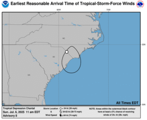
Storm path
Chantal leaves thousands without power across NC towns
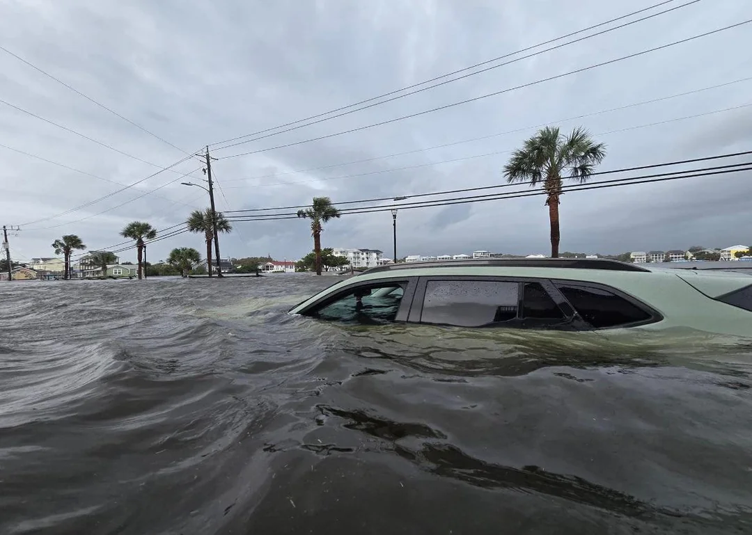
When Tropical Storm Chantal hit early Sunday, it soaked North Carolina with nearly 10 inches of rain in some towns, leaving a path of chaos in its wake. Chapel Hill, Carrboro, and Southern Pines were especially hard-hit, with water swallowing roads and snapping power lines. About 60,000 people lost electricity. In Southern Pines, a dam even collapsed, flooding nearby areas. According to the National Weather Service, the storm traveled northeast at 15 mph and had winds reaching 30 mph by Monday morning. Flash floods covered neighborhoods, and authorities confirmed two tornadoes struck central parts of the state. While no injuries or deaths were reported, the scale of damage points to how fast these storms can turn everyday life upside down—especially when they hit inland towns that aren’t used to tropical weather.
Emergency rescue
Trapped drivers saved as rain floods busy intersections
Drivers in Chapel Hill and Durham found themselves stuck in rising waters, caught in traffic that turned into dangerous rivers within minutes. Local rescue teams responded to more than 50 emergency calls within 12 hours on Sunday. Fire Chief Mike Cameron in Southern Pines reported three people were rescued from submerged vehicles after a private dam gave way. Across central North Carolina, emergency responders used boats to get stranded residents to safety. Nearly 60% of the rescues were from low-lying roads near creeks and underpasses. These rapid responses were made harder by downed trees and washed-out roads. Meteorologists like Frank Pereira warned people not to travel unless absolutely necessary. The truth is, even a few inches of water can stall a car, and just 12 inches can carry it away. That’s how real—and fast—the danger comes.
Rainfall records
Some towns drown under 10 inches of rainfall in a day
In just 24 hours, parts of North Carolina saw more than a month’s worth of rain. According to the National Weather Service, Chapel Hill recorded over 9.7 inches of rainfall, breaking previous July records. Carrboro and Pittsboro weren’t far behind, each logging more than 8 inches. What’s alarming is that flash floods formed not just near rivers but in driveways, parks, and shopping centers—areas that normally stay dry. NOAA reported that storms like this are becoming more frequent, especially in the Southeast, due to warming oceans fueling stronger weather systems. It’s not just the coast that needs to prepare anymore. Even places 200 miles inland now face the kind of rain once expected only in hurricane zones.
🔹Quick Fact Box🔹
-
🌧️ Chapel Hill got 9.7 inches of rain in 24 hrs
-
🚧 Over 50 emergency rescues happened on Sunday
-
💡 Nearly 60,000 homes lost power in North Carolina
-
🌀 Atlantic hurricane season runs June 1 to Nov 30
-
⚠️ 13–19 named storms predicted by NOAA for 2025
Power outage
Downed lines shut off electricity for 60,000 residents
By Sunday night, nearly 60,000 homes in North Carolina were in the dark. Duke Energy and local electric co-ops scrambled to restore power as fast as possible, but the damage was spread out. In Carrboro and Durham, live wires tangled with fallen trees made it too dangerous for crews to start work right away. Over 100 utility trucks were deployed across central NC, but muddy roads and washed-out access points slowed progress. The Department of Energy noted that storms with heavy rain and wind, even when not hurricanes, now cause about 70% of large-scale outages in the Southeast. And the longer people go without power, the more risks rise—think food spoilage, heat exhaustion, and missed emergency alerts. For many, it’s a reminder to keep a storm kit handy and always have a backup battery for essentials.
Storm warnings
Flood alerts hit 6 states as storm heads northeast
As Chantal moved northeast on Monday, flood warnings extended across Virginia, Maryland, Delaware, Pennsylvania, and even parts of New Jersey. The National Hurricane Center issued alerts through its interactive map, noting that urban areas face the greatest risk due to poor drainage systems. In cities like Baltimore and Trenton, drainage grates clogged quickly, and emergency crews pre-positioned pumps in vulnerable neighborhoods. Heavy surf and rip currents also closed beaches along parts of the East Coast. Meteorologist Frank Pereira mentioned on NPR that inland flash flooding now causes more deaths than coastal storm surges—mainly because people don’t expect danger miles from the ocean. Chantal may be weakening, but the trail it leaves behind is far from over.
Dam failure
Private dam collapse floods neighborhoods near Pines
Southern Pines wasn’t ready for the sudden surge that hit after a privately owned dam gave way on Sunday. The dam break sent a wall of water downstream, flooding nearby homes and causing evacuations. Local officials said this kind of failure isn’t new—North Carolina has over 3,000 aging dams, with nearly 8% rated “high hazard” by the American Society of Civil Engineers. What made this one worse was that the heavy rain had already saturated the ground, so the burst water had nowhere to go. Within minutes, roads were underwater, and three people were rescued from their cars. The incident is sparking questions about dam inspections, as private owners often lack resources for proper upkeep. It’s a scary wake-up call: not all storm damage comes from the sky—some of it breaks from behind.
Climate crisis
Warmer oceans feed stronger, faster storms inland
Storms like Chantal are getting stronger because of warmer waters in the Atlantic. NOAA’s Climate Prediction Center reported sea surface temperatures in June were 1.3°F above average. That might not sound like much, but it gives storms more fuel to form faster and dump more rain. Scientists at Yale Climate Connections say that even weaker storms, like tropical depressions, can now cause historic flooding because they move slowly and carry tons of moisture. Last year, hurricanes caused $118 billion in damage across the U.S., making it one of the costliest seasons ever. And here’s the kicker: North Carolina is hundreds of miles from the coast, but it’s still facing flood risks like never before. Climate change isn’t coming—it’s already reshaping how, where, and when these storms hit.
Storm season
Forecasters warn: brace for more storms through November
The Atlantic hurricane season runs from June 1 to November 30, and this year is expected to be especially busy. The National Oceanic and Atmospheric Administration predicts 13 to 19 named storms, with at least 4 likely to become major hurricanes. Tropical Storm Chantal is the third storm already, with Barry and Andrea forming earlier this summer. In the past decade, the average number of storms has gone up significantly, and 2024 was one of the costliest years for hurricane damage in U.S. history. Forecasters are urging people—even those inland—to update their storm plans now. That includes checking flood insurance, keeping phones charged, and knowing evacuation routes. The scariest thing about these storms isn’t just the wind or rain—it’s how fast everything can change.
Final warning
Act now: storms are faster, stronger, and less forgiving
Tropical Storm Chantal didn’t wait for a warning siren to change lives—it just came. That’s the new reality. Families are waking up to floodwater in their living rooms, kids are being carried from cars by firefighters, and towns that used to feel safe now feel fragile. As author and storm survivor Rebecca Sanders once said, “You think you have time until the water’s at your door.” That quote sticks. Because no one should be caught off guard again. Check your emergency plans, talk to your neighbors, and treat every warning like it’s personal. Chantal was just one storm. But it showed us we’re all in the storm zone now.
Share this content:


Post Comment